Hike the Sand Canyon Trail in Canyons of the Ancients National Monument.
Keep your eyes peeled for archaeological sites on the 6.5-mile hike.
Note: The sites along the Sand Canyon Trail are closed to public access. Please do not enter them, climb on walls, move artifacts, or touch petroglyphs. It is helpful to have binoculars for this hike.
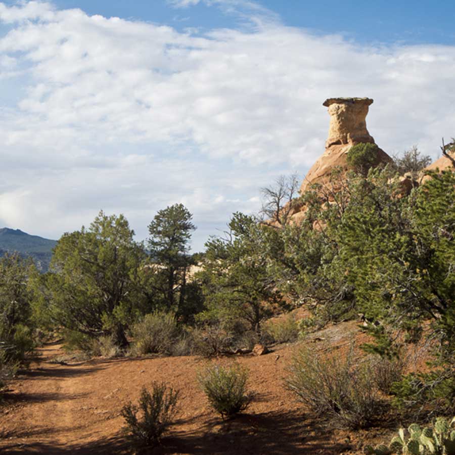
You begin by walking up the gently sloping Navajo Sandstone toward the left side of a small rugged rock outcrop known as Castle Rock. The faint remains of a pueblo with 40 rooms and 16 kivas is clustered around Castle Rock, although only a few standing walls remain. After climbing a small hill, you’ll see a spur trail that leads to a small standing wall a hundred feet off the main trail. Please respect the “area closed” sign near the wall.
Within a couple hundred feet of the trail to the wall, you reach another junction. This is the bike trail coming from the East Rock Creek Trail. Continue straight up the slickrock slope, where you reach a third junction. This is the trail you will return along on the route laid out in this trail description.
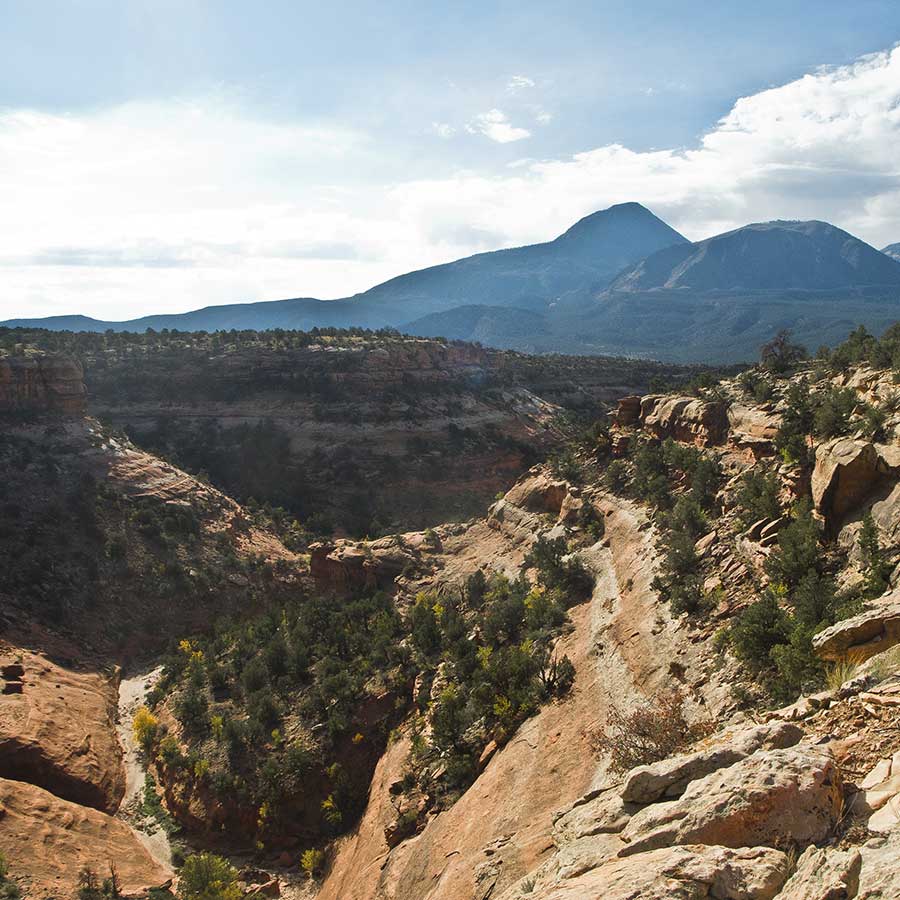
Continue straight ahead, then bear right, leaving the slickrock behind. The trail follows the base of a bluff of Entrada Sandstone, the geologic layer containing the alcoves where prehistoric residents built the cliff dwellings seen on this hike. After passing a low circular wall of stacked rocks, the trail curves to the left around the bluff; at roughly 0.8 mile a spur trail (marked by a post) goes to three small alcoves with no cliff dwellings.
Saddlehorn Pueblo
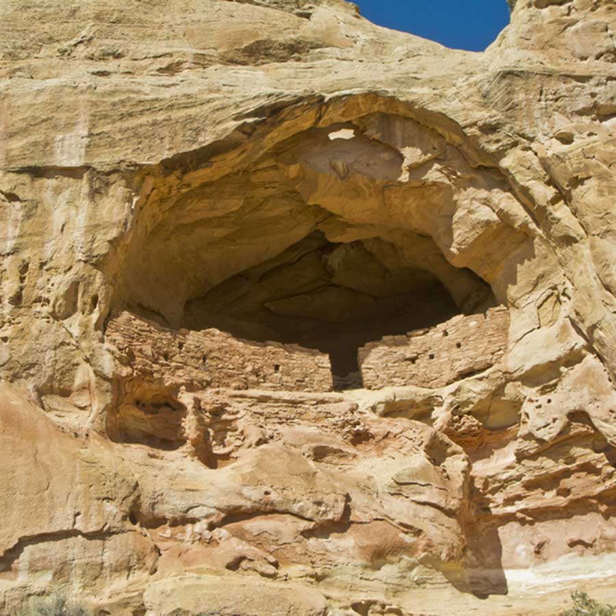
Saddlehorn Pueblo, named for the spire of rock above the alcove, appears on the left at 1.4 miles. The cliff dwelling has two rooms in the alcove and two rooms on the pinnacle above the alcove. Near the alcove is a kiva that had likely burned; it was excavated in the late 1980s. Saddlehorn Pueblo was probably occupied at the same time as Castle Rock Pueblo. Please do not enter the site.
The trail wraps around a point of rock where a large butte of Junction Creek Sandstone capped by the Morrison Formation appears. The Junction Creek Sandstone is composed of sand dunes that formed 150 million years ago and the Morrison Formation is made up of sediment deposited in river beds, floodplains, and lakes 140 million years ago. The trail leaves the bottom of the bluff and approaches the edge of Sand Canyon; a few spur trails lead to overlooks with great views into Sand Canyon and the “head” of Sleeping Ute Mountain to the south.
East Rock Creek
At 2.1 miles you reach a junction with a trail coming in from the left that goes to East Rock Creek. This is the trail you take for this hike. If you would rather continue up Sand Canyon, go straight. After turning left, you hike up towards a small saddle, but rather than crossing the saddle, the trail climbs a few switchbacks to the top of the Entrada Sandstone mesa. Below, you can see the Sand Canyon Trail you just walked along.
The trail stays on top of the mesa and bears right towards a towering promontory of Junction Creek Sandstone. After dropping into a small drainage, you will pass the mouth of a short tunnel most likely dug by a prospector looking for mineral riches. At 3.0 miles, you reach another junction. To see a large natural arch, go right at this junction and follow the trail for 0.6 mile. The nicely shaped, muscular arch is high on the face of the cliff to your right.
To skip the arch, go left at the junction along an abandoned road that drops down towards the broad floor of East Rock Creek. As you walk along the road, look in the distance to the right for cliff dwellings tucked into alcoves. The trail reaches a pouroff at about 4.4 miles, and you can see the remains a few small structures in two alcoves on the north side of the drainage below the pouroff.
At 4.8 miles, you reach another junction with a trail coming in from the left. Take this trail, which leaves the road behind and angles up a slope towards a point of Entrada Sandstone. Look left at the skyline to see a low wall of stacked rocks. The trail loops around the point and soon you get a more complete view of the low rock walls on the skyline. There is also a well-preserved standing wall just below a rounded dome of white sandstone to the right of the rocks on the skyline.
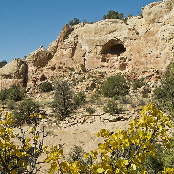
At 5.5 miles you reach a very nice cliff dwelling with the entrance in the center of the wall. A short spur trail gets you closer to the site, but please do not go beyond the area closed sign. Note the small arch above the site in the roof of the alcove. After leaving the site, the trail goes around the head of the small canyon and down the other side, providing more views of the cliff dwelling.
The trail continues along the base of the cliff, through junipers, cliff rose, and yucca as it wanders towards the junction you passed at the beginning of the hike. Castle Rock comes into view, and you soon reach the junction, where you go right and return across the slickrock to the trailhead.
Directions to Sand Canyon Trailhead
From Cortez: Starting in downtown, drive south on U.S. Highway 160 3.4 miles to County Road G, also known as the McElmo Canyon road (look for a sign for Hovenweep National Monument); turn right and drive 12 miles. The trailhead is on the right side of the road soon after you cross a bridge.
From Hovenweep National Monument: Leaving the monument, turn left on County Road 213/413, drive 6 miles to County Road 401, turn left, drive 4.4 miles to County Road 402/G, turn left and drive 17 miles to the trailhead, which will be on your left.
General Location Canyons of the Ancients National Monument, southwestern Colorado
Closest Towns Cortez, Colorado
Distance 6.5 miles (10.5 km)
Difficulty Moderate
Trailhead Elevation 5,450 ft (1,660 m)
Highest/Lowest Elevation 5,900/5,450 ft (1,800/1,660 m)
Maps USGS Quad: Battle Rock, Colorado
Managed By Canyon of the Ancients National Monument, BLM
Fees No fee – Check the website below for current information.
Pets Allowed
More Info BLM website

Special membership offer
Join the Grand Canyon Trust today to receive your adventure kit:
- $25 donation: a Grand Canyon map, The Advocate magazine subscription, bookmark, and sticker
- $75 donation: everything above plus four stunning note cards
- $100 donation: all the benefits of the $75 level, plus a Grand Canyon Trust hat