Identified Uranium Resources in the United States Map

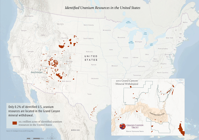
There are currently 10.1 million acres of identified uranium resource areas in the United States, of which only 0.2 percent are located in the Grand Canyon mineral withdrawal area. (Identified areas do not represent quantity, quality, or availability of uranium resources.) Uranium resource areas are areas speculated to contain uranium. These are different from uranium reserves and estimated resources, which reflect actual or speculative quantities of uranium based on sampling or extrapolation from existing data. We mapped the uranium resource areas because data about the locations of reserves and estimated resources are not publicly available. View on the map ›

Identified uranium resources in the United States

Download your copy ›

Resource - map credit Stephanie Smith

Maps and graphs may be used for non-commercial purposes provided that they are not altered or edited and they are appropriately credited. All map products should be credited to Stephanie Smith, Grand Canyon Trust, unless otherwise noted. A hyperlink to the Grand Canyon Trust website is appreciated.

For higher quality images or custom sizing please contact our communications director, Ashley Davidson, at adavidson@grandcanyontrust.org.

Related Resources

A December 2024 poll of 500 Arizona voters by public opinion research firm GQR found strong public support for Baaj Nwaavjo I’tah Kukveni – Ancestral Footprints of the Grand Canyon National Monument, which protects precious water sources and the ancestral homelands of Native American tribes near Grand Canyon National Park. Download the poll memo › Download […]

This map shows the risk of fatal accidents along the more than 300-mile transportation route from Canyon uranium mine (renamed Pinyon Plain Mine) near the Grand Canyon to the White Mesa uranium mill. Four of the five most dangerous sections along the route are on the Navajo Nation. See a photo gallery of the haul route, […]