Fatal Accident Risk Along Pinyon Plain Haul Route Map

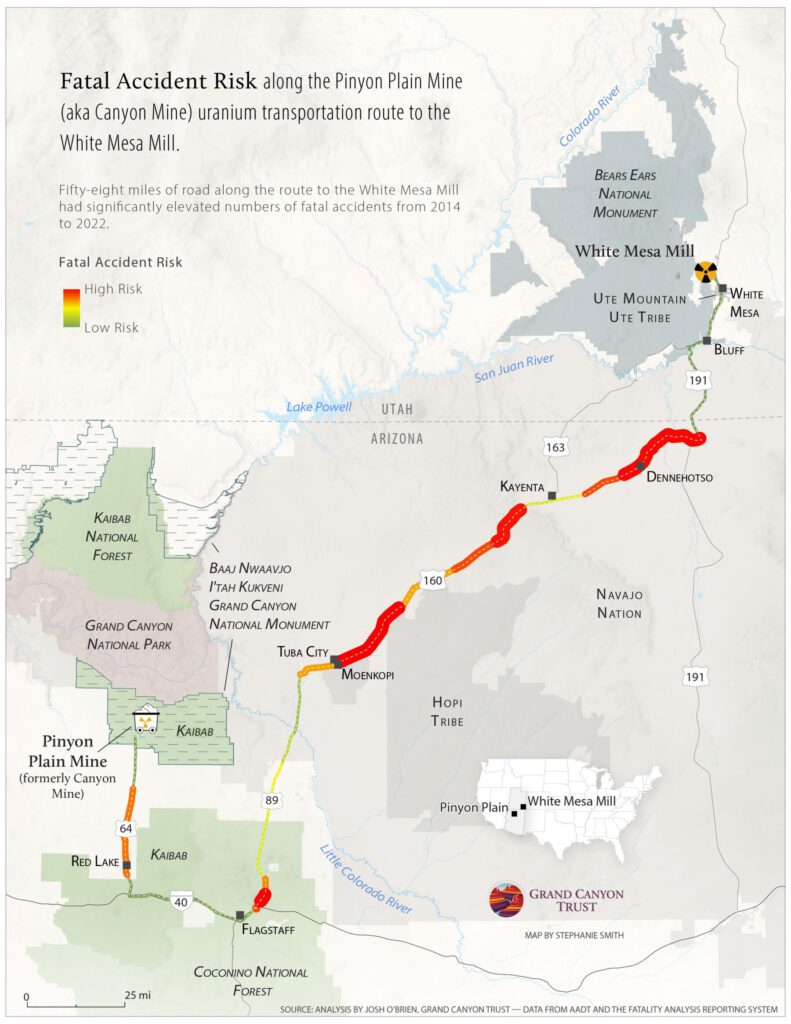
This map shows the risk of fatal accidents along the more than 300-mile transportation route from Canyon uranium mine (renamed Pinyon Plain Mine) near the Grand Canyon to the White Mesa uranium mill. Four of the five most dangerous sections along the route are on the Navajo Nation.


See a photo gallery of the haul route, with photos and videos available for media and educational use ›


Fatal Accident Risk along Pinyon Plain Haul Route Map. Map by Stephanie Smith, data analysis by Josh O'Brien

Download the PDF ›

Resource - map credit Stephanie Smith

Maps and graphs may be used for non-commercial purposes provided that they are not altered or edited and they are appropriately credited. All map products should be credited to Stephanie Smith, Grand Canyon Trust, unless otherwise noted. A hyperlink to the Grand Canyon Trust website is appreciated.

For higher quality images or custom sizing please contact our communications director, Ashley Davidson, at adavidson@grandcanyontrust.org.

Blog - P2A CTA - Urge tighter regulations for Canyon Mine

Close and clean up Canyon Mine (renamed Pinyon Plain Mine)

Related Resources

A December 2024 poll of 500 voters across Utah by public opinion research firm New Bridge Strategy found strong public support for Bears Ears and Grand Staircase-Escalante national monuments, and for national monuments generally. In addition, nearly nine in 10 Utah voters say it is very important for tribes to have a strong role in […]

A bar graph showing in pink 75% of Utah voters support presidents' ability to protect public lands as national monuments, compared to 25% who oppose in gray bar, from the 2024 Utah National Monuments Poll
Utah voters strongly support national monuments and Bears Ears and Grand Staircase-Escalante in particular a December 2024 poll shows.