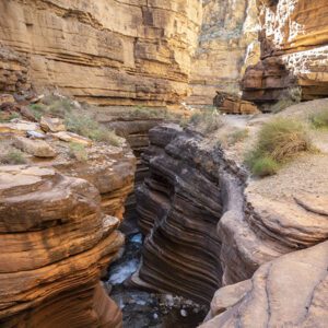
Known for its colorful swirls of slickrock, Vermilion Cliffs National Monument is a sherbet-colored dream world.
It’s filled with fantastical rock formations like The Wave, White Pockets, and Buckskin Gulch.
This 280,000-acre monument bumps up against the Utah/Arizona border, where the wooded Paria Plateau stretches south, dropping 3,000 feet at the monument’s namesake — the Vermilion Cliffs. Paria Canyon, a slot canyon along the Paria River, cuts across the northeast corner of the monument and offers an immersive wilderness experience.
Visiting Vermilion Cliffs National Monument
Most people visiting the monument today come to see The Wave, Buckskin Gulch, and Paria Canyon, which are all located in the northwest part of the monument generally called Coyote Buttes. These incredibly scenic features, with their vibrant colors and intriguing forms, attract photographers, artists, and tourists alike. Once little visited, the area is now so popular that people compete for the chance to see the sandstone formations and sinuous slot canyons. Hundreds of people vie daily (through a lottery and walk-in system) for the 48 permits the BLM issues for Coyote Buttes North (The Wave). Overnight trips in Coyote Buttes South (Buckskin Gulch and Paria Canyon) also require competitive permits, but visiting these canyons is worth the advanced planning. With miles of constricted walls, Buckskin Gulch is the longest slot canyon in the world. You can acquire day-use permits for Buckskin Gulch and Coyote Buttes South at certain trailheads. Find out how you can get a permit
Trails: Wire Pass to Buckskin Gulch
Campgrounds: Stateline Campground
Visitor Centers: Kanab Visitor Center (in-person lotteries for Wave and Coyote Buttes South) | Paria Contact Station
Nature Guides: Native Plants of the Vermilion Cliffs | Bats in Vermilion Cliffs | Songbirds
Highway 89A follows the base of the brilliant Vermilion Cliffs, tracing part of the Honeymoon Trail—a route taken by newlywed Mormons across the Arizona Strip to solemnize their vows at the Church temple in St. George, Utah. Before Mormons or cowboys settled in the area though, Native Americans called the region home. Ancestral Puebloans and Southern Paiute lived in the area, and you can see rock art, the West Bench pueblo site, and cultural remnants that tell of their presence.
Vermilion Cliffs is also the site for reintroduction of the California condor. There is an interpretive viewing area along the House Rock Valley Road, with good chances of seeing these huge vultures perched on the rock walls.
Getting there
House Rock Valley Road (BLM 1065) is the main access route in the monument that connects to other dirt roads and trailheads. From Kanab, Utah, head east on Hwy 89 towards Page, Arizona, or head south on Hwy 89A through Jacob Lake—House Rock Valley Road runs north/south between these two highways.
Roads in the monument are unpaved, often washboarded or filled with deep sand, and may require 4WD depending on conditions. BLM recommends carrying a spare tire, and extra gas, food, and water since no services are available. Get a map at the BLM visitor centers in Kanab and St. George, or the Jacob Lake visitor center before traveling into the monument.
General Location Utah/Arizona border
Closest Towns Page, Arizona and Kanab, Utah
Cost Permits required to visit certain areas of the monument
Managed By Bureau of Land Management
More Info BLM website
Adventure awaits
Sign up to get monthly hikes in your inbox for a year.

Special membership offer
Join the Grand Canyon Trust today to receive your adventure kit:
- $25 donation: a Grand Canyon map, The Advocate magazine subscription, bookmark, and sticker
- $75 donation: everything above plus four stunning note cards
- $100 donation: all the benefits of the $75 level, plus a Grand Canyon Trust hat
Related Hikes by Destination

Distance: Up to 13 miles
Difficulty: Easy
Type: Point-to-point

Distance: 6.6 miles (10.6 km) one way
Difficulty: Moderate
Type: Out and back

Distance: 9.5 miles (15.3 km)
Difficulty: Strenuous
Type: One way

Distance: 27.9 miles
Difficulty: Strenuous
Type: Out and back

