Get a taste of the Cedar Mesa hiking on this route through Kane Gulch to Stimper Arch
Experience Bears Ears National Monument and see two archaeological sites along the way on your hike through Kane Gulch to Stimper Arch.
From the Kane Gulch Ranger Station, cross UT 261 and pick up the signed trail on the west side of the road. The broad, sandy wash soon turns into a thick tunnel of willows, and you pass a spring, several small pools, and an aspen grove unusual at this elevation.
As Kane Gulch slices through the Cedar Mesa Sandstone, the canyon deepens dramatically. House-sized boulders clog the wash, and it becomes increasingly difficult to walk in the creekbed.
Several small pouroffs force you to take a brief detour up the canyon walls. Watch for cairns and trails on the north side of the canyon that bypass these obstacles.
Around 2 miles, the trail crosses over to the opposite side of the canyon above a huge pouroff and gradually returns to the streambed. Continue following the canyon’s meanders as the trail cuts across high banks.
Approaching Grand Gulch proper, keep your eyes peeled for archaeological structures on ledges across the canyon.
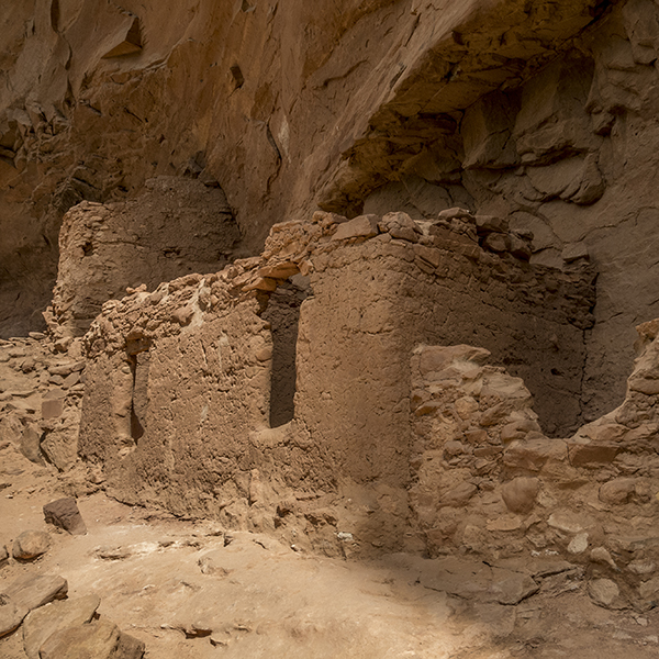
Junction Ruin
Junction Ruin, named for its location near the confluence of Kane Gulch with Grand Gulch, is an extensive three-level site. To visit it (3.5 miles from the trailhead), turn right on a foot trail heading north up Grand Gulch. Make your way over to the base of the west wall, and pass an excellent campsite shaded by cottonwood trees. You’ll see the site on a series of ledges.
The midden is roped off, and you can find interpretive materials in an ammo can chained to one of the posts.
Enjoy peeking inside the storage rooms and dwellings of this early puebloan home, but avoid touching structures and rock art or entering any rooms. These fragile cultural resources need to be explored with care—foot traffic alone causes deterioration.
Turkey Pen
To reach the next site, turn around and walk south down Grand Gulch for 0.8 mile. Head towards an alcove on the west side of the canyon.
Here you’ll find more storage rooms, kivas, habitation rooms, and rock art. But the highlight of this site is a “turkey pen,” so named for a brush and mud (jacal) enclosure that now looks like a bunch of sticks stuck in the sand.
Turkey droppings found throughout the site suggest that the Ancestral Puebloans who lived here as early as A.D. 1 to 200 did raise turkeys. But the site’s name is a bit of a misnomer, because archaeologists do not believe that the Ancestral Puebloans confined the turkeys to pens or enclosures.
Note: Part of the site is closed to visitation. Please respect the sign and do not enter the roped off area.
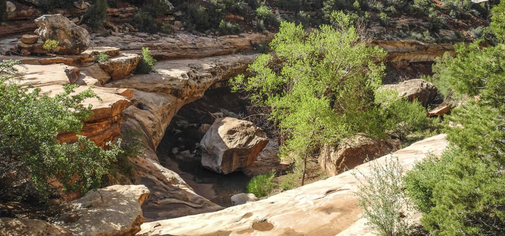
Stimper Arch
From Turkey Pen, Stimper Arch is a short jaunt downcanyon. Its opening spans 20 feet across and 6 feet tall. While you can continue down Grand Gulch, Stimper Arch serves as a good turn-around point for a day hike.
Directions to the trailhead
From the junction of UT 95 and UT 261, about 32 miles from Blanding, drive south on UT 261 for about 4 miles. The Kane Gulch Ranger Station is on your left. Park your vehicle here, and get the required day-use permit from inside the station (if open) or at the self-serve kiosk.