 by Travis Bruner, Arizona Forests Manager
When something is on fire, what does your first instinct tell you to do?
Put it out.
Fire suppression (firefighting) is the most immediate and conspicuous response to wildfires. However, it is also the most expensive way of addressing huge blazes. In 2016, the U.S. government spent nearly $2 billion of taxpayer dollars suppressing fires on public lands.
So far this summer, 62 wildfires have burned across Arizona. Some of these fires have presented problems, burning whole stands of trees, leading to floods, wildlife habitat degradation, and threats to human life and homes. But others have been “good” fires — clearing out small trees, releasing nutrients into the soil, and improving the biodiversity of forest understories.
Though it may seem counter-intuitive, the return of fire to forest lands — when correctly planned and managed — can actually reduce the potential devastating effects from wildfires and benefit our landscapes in countless other ways.
Through the Four Forest Restoration Initiative (4FRI), the Grand Canyon Trust has been working with community partners and the Forest Service to implement ecologically sound forest restoration work on the Coconino, Kaibab, Tonto, and Apache-Sitgreaves national forests in Arizona.
On the ground, we’re working toward restoring these forests to their historic character — well-spaced trees of various ages and sizes.
While we use machines to cut trees down and thin tree stands, we also use fire to improve the health of our forests. Fire is the primary natural process that keeps forests from becoming unbalanced in problematic ways, and represents one of the sharpest and most effective tools in forest restoration.
First, the Forest Service completes an analysis and burn plan for the prescribed fire.
On the day of the burn, an in-depth briefing occurs on site first thing in the morning, with all personnel meeting to coordinate their roles for the day, such as ignition and “holding” (holding the fire on the intended path). This briefing covers topics like humidity, temperature, wind direction and speed, safety issues, the burn plan, and objectives for the fire. Objectives might include goals like exposing mineral soils or targeting trees below a particular diameter.
The crew sends up a helium balloon to test wind directionality, lift, and speed. This helps predict how smoke will move through the air once the fire is ignited. If the balloon’s behavior is consistent with the goals of the burn plan, the crew moves on to a test fire. This involves igniting a small area to test whether it is dry enough to burn and whether its behavior and effects are desired.
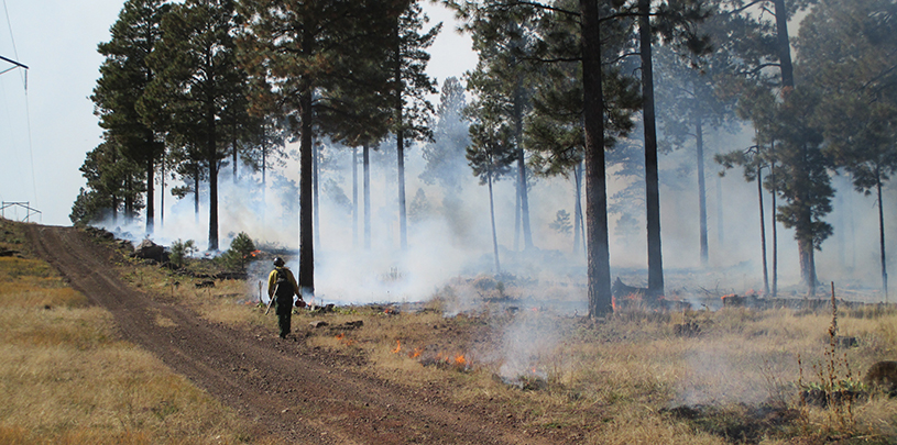
 Photo: Mary Lata, USFS
If the test looks right, based on fire behavior and fire effects, the Forest Service goes forward with the prescribed fire, with all crew members communicating by radio. The burn boss supervises an ignition boss and holding boss. Fire engines sit on site to provide water if/as needed. There are also contingency resources (could be dozers, engines, handcrews, etc.) identified for all prescribed fires on public lands. If near a major roadway, some folks go out to the road to monitor smoke movement, so measures can be taken if things don’t go as planned.
Wind, weather, and fire behavior and effects are documented throughout the fire, which may last anyway from one day to a week. Three days after the last smoke has been seen, Forest Service staff go out to verify that the fire will not escape beyond the planned prescribed fire boundary.
In 4FRI, the Forest Service uses controlled burns not only to accomplish restoration objectives, but also to save taxpayers from paying the huge costs associated with fighting severe wildfires. A win-win for all.
A special thanks to Mary Lata, 4FRI Fire Ecologist, and Victor Morfin, Forest Fuels Specialist for the Coconino National Forest, for describing how a prescribed fire is put on the ground.
You have the opportunity to comment on how you think some of the most beautiful landscapes in Utah should be managed for the next generation to come.
Read MoreTree ring data helps scientists and land managers protect old-growth pinyon and juniper trees.
Read MorePack your camera and head for the trees! The Colorado Plateau has some of the best displays of fall foliage all season long.
Read More